San Rafael Waterfall
San Rafael Waterfall
Collapsed in February 2020, Ecuador's former highest waterfall remains a major observation site on the Quito–Lago Agrio route, facing Reventador volcano.
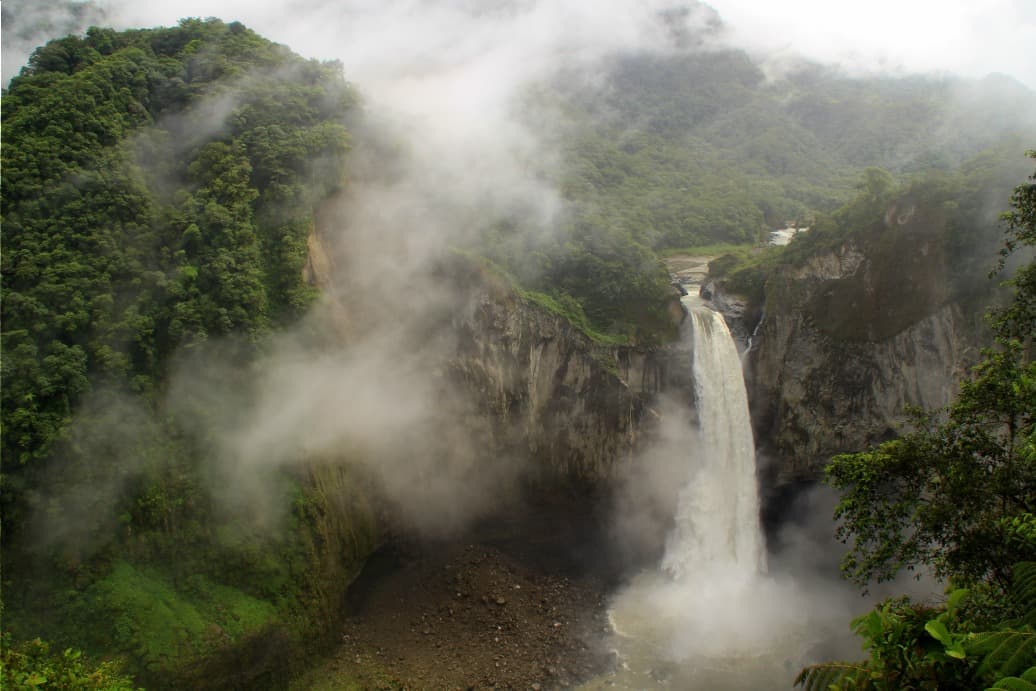
San Rafael waterfall was, until February 2, 2020, Ecuador's highest cascade. Located on the border between Napo and Sucumbíos provinces, on the flank of Reventador volcano, it collapsed following the formation of a sinkhole upstream, a phenomenon attributed to the Coca Codo Sinclair hydroelectric project commissioned in 2016. The site remains accessible: visitors today experience the viewpoint overlooking the canyon, the Quijos river, and the smoking cone of Reventador.
Why visit San Rafael Waterfall
The site retains considerable interest despite the disappearance of the main cascade. It allows visitors to directly understand the effects of hydroelectric development on an Amazonian ecosystem and offers one of the clearest vantage points over Reventador, an active stratovolcano. The access trail crosses dense humid forest within Sumaco-Napo-Galeras National Park, designated a UNESCO Biosphere Reserve in November 2000. Wildlife includes spectacled bears, deer, and pumas, along with rich Amazonian birdlife.
The detour fits logically on the Quito–Lago Agrio route, halfway between the Andes and the Amazon, during an itinerary toward Tena or Cuyabeno reserves.
History of a vanished waterfall
Before the collapse, San Rafael presented a double cascade with a total height of approximately 150 meters: a first section of 40 meters followed by a main drop of 120 meters, across a width of roughly fifteen meters. The flow, fed by the confluence of the Quijos and El Salado rivers, reached approximately 400 m³ per second.
From construction in 2016 of the Coca Codo Sinclair dam upstream, Ecuadorian hydrologists warned of the risk of altering the sedimentary regime of the Coca River. On February 2, 2020, a regressive collapse (sinkhole) immediately upstream of the cascade caused the waterfall to disappear, with the watercourse now descending into the canyon through three smaller cascades. Regressive erosion continues toward the dam and threatens E20 road infrastructure.
What to see on site
The access trail
From the entrance post at roadside, a maintained trail of approximately 1.5 km descends through humid forest to the viewpoint. The shaded route allows observation of bromeliads, tree ferns, and Amazonian birdlife. Allow 1 to 2 hours round trip depending on pace.
The viewpoint
The observation platform, built before 2020 facing the cascade, now offers a sweeping view over the Quijos river canyon and the new cascades formed by the collapse. On clear days, Reventador volcano is visible in the background. It's the best vantage point to grasp the geomorphological scale of the site.
The natural pool
Below, a basin fed by the Quijos river was once used for swimming. Given the modifications to the watercourse and irregular flow, swimming is now inadvisable. Check guidelines posted at the entrance.
Practical information
- Paid access at a modest rate, payable at the trail entrance
- Allow a half-day on site, including the hike
- Closed shoes essential, trail slippery after rain
- Bring waterproof jacket, insect repellent, and water
- No food service on site: supplies at El Chaco
- Weak or absent cell network in the area
Trail status may vary depending on rainfall and ongoing regressive erosion. Consult the Ministry of Environment (MAATE) or local operators before departing.
When to go
The equatorial Amazonian climate means rain falls year-round. The least humid period typically extends from November to February, with clearer mornings favoring Reventador observation. April through July correspond to the heaviest rains: muddy trails, strong flows, reduced visibility. Plan an early morning visit, as cloud cover often develops by early afternoon.
How to get there
The waterfall is located on Route E20 between Baeza and Lago Agrio, roughly 4 hours by bus from Quito. From Quitumbe terminal, take a bus heading toward Lago Agrio and ask to be dropped at San Rafael or El Chaco, a waypoint village upstream. Several companies serve this route daily.
By vehicle, count approximately 3.5 hours from Quito via the eastern Andean road through Papallacta and Baeza. From Tena, access is from the north ascending the Quijos valley. Day excursions are also offered from Quito and Baeza.
What to see in the region
The Quijos region suits an ecotourism itinerary combining mountain and Amazon. A few stages to combine with this visit:
- Tena, capital of Napo province and gateway to the Amazon
- The Pastaza River, another major watercourse of the Amazonian piedmont
- Cuicocha Lake, on the return to Quito via the northern highlands
- Baeza and the Quijos valley, renowned for trout fishing and rafting
- Reventador volcano, accessible via a demanding 2-day trek
Frequently asked questions
The main cascade collapsed on February 2, 2020, following a sinkhole upstream. The site remains visitable from the viewpoint, but the waterfall itself has vanished and been replaced by several smaller cascades in the canyon.
Ecuadorian geologists link the collapse to the Coca Codo Sinclair hydroelectric project commissioned in 2016. The dam altered the sediment load of the Coca River, triggering regressive erosion that eventually destabilized the waterfall's threshold.
Swimming in the Quijos river basin is now inadvisable due to flow fluctuations and sedimentation changes. Follow guidelines posted at the site entrance.
Allow 2 to 3 hours on site, including 1 to 2 hours for the round-trip hike to the viewpoint. A half-day is comfortable from Baeza or El Chaco.
From Quitumbe terminal, take a bus to Lago Agrio (approximately 4 hours) and get off at San Rafael or El Chaco. By car, count 3.5 hours via Papallacta and Baeza.
Plan your Ecuador trip
San Rafael Waterfall fits naturally into an itinerary linking the Andean highlands to the Amazon. To build a coherent stay combining volcanoes, humid forests, and Kichwa communities, consult our Ecuador travel ideas.
Interested in this visit?
We can include it in your personalised itinerary.